

Explore
SUGAR HILL CONSERVATION AREAS
Overlook Farm

Thanks to the generosity of the late Rufus Perkins, a founding member of ACT, one of our valley’s most special places is protected for all time.
In December 2019, Rufus placed a permanent conservation agreement on his 300 acres off Hadley Road in Sugar Hill. “I and generations of my family have enjoyed this land and cared for it,” said Rufus when the project concluded. “To know that it will now always be in a natural and undeveloped state and available to the community brings me real satisfaction.”
The Overlook Farm property features open fields lending a spectacular and unique view of the Franconia and Presidential ranges. A quaint cabin was built with logs salvaged from the 1938 hurricane. Inside the cabin hangs a watercolor of the farm, a poem praising the hills, and a narrative about the farm history and that of the cabin itself. The property has a network of walking/XC ski trails that Rufus worked on for years and that ACT volunteers are now helping to maintain. A state snowmobile trail also traverses the land.
The property also tells the story of the region’s agricultural past. Of the several 19th-century cellar holes, the most prominent are the old Overlook Farm house and barns for which the property is named. While the farm site is forested today, after the Civil War, Sugar Hill was mostly open fields and pasture land. This property was featured as an example of the region’s land use changes in “Where the Great River Rises: An Atlas of the Upper Connecticut River Watershed” (UPNE, 2009).
This has been a special place for years. Inside the cabin, generations of visitors have signed a succession of guest books. Births, deaths, anniversaries, and friendships have all been noted here.
Here are some examples:
So awesome to be back. Have come for many years, often with my father, who loved to come here. Thank you so much for maintaining this wonderful cabin and making it available to all of us. It is a treasure and a gift that is deeply appreciated!
It’s our 18th anniversary & second trip to the cabin. Nothing like this anywhere else we’ve been. Thank you for allowing us to visit and thank you Dave for bringing us here.
Our dear friend Simon showed me the cabin well over a dozen years ago. There was at least two feet of fresh snow! . . . Simon passed a year and half ago. I can hear his laugh, see his smile, feel his love when I visit this cabin. This place will always be special to me.
The Overlook Farm is part of the Bronson Hill Conservation Area. It includes the privately owned Perkins-Porter Family Preserve and the Foss and MacCornack-Evelyn Forests owned by ACT. Together, these lands comprise over 600 acres available for public enjoyment. Also nearby is the Cooley-Jericho Community Forest (CJCF), which hosts another group of excellent trails and multi-use recreation opportunities.
Perkins-Porter Family Preserve

The open fields and undeveloped ridgeline of the Perkins-Porter Family Preserve are a prominent view from Main Street, the town hall, and the community house. In several surveys about the town's future, Sugar Hill residents named this land as an important scenic value that ideally would be conserved.
Thanks to the generosity of Rufus Perkins, his brother Jim, and their sister Louisa – a family with deep roots in Sugar Hill – over 120 acres of fields and woods on Bronson Hill were permanently protected from development in August 2009. The family’s willingness to permanently protect the outstanding scenic hillside – as well as allow public enjoyment of it – stands as a testament to their commitment to ACT, our values, and to the community.
The siblings trace their love of the area to their great grandfather’s arrival in Sugar Hill in 1885. “We spent many summers as children and all seasons as adults either on Sunset or Bronson Hill,” Rufus said. “The long family connection and our appreciation of the special nature of the place made us want to keep it as it is for future generations to enjoy.”
The Perkins-Porter Family Preserve abuts Overlook Farm, conserved by Rufus in 2019, as well as ACT’s Foss Forest and the MacCornack-Evelyn Forest, the latter being the generous gift from another family with deep local roots. The combined 600 acres form a significant unfragmented tract of forestland that is home to wildlife and enjoyed by many for the walking trails and splendid views.
Sunset Hill Golf Course

The Sunset Hill Inn is located in the heart of Sugar Hill. The inn and its golf course - the oldest 9-hole course in N.H. - are so much a part of the heritage and character of this small town, they seem like they've always been there and always will.
But in 2002, a real threat emerged. The golf course and the inn had fallen into separate ownerships, and a Massachusetts real estate developer was proposing turning the golf course into condos. Instead, the community rallied to "Save the Sunset" and ACT raised over $350,000 to conserve the 60+ acre golf course and surrounding woodlands. As a result, the golf course was reunited with the inn, which the inn owners deemed crucial to protect and grow their business. In the winter, the land is open to the public for XC skiing or snowshoeing, and in the summer the golf course is terrific!
The NH Land and Community Heritage Investment Program (LCHIP) and the Island Foundation, as well as the generosity of over 300 individual donors, made the project successful.
Foss Forest

Instead of growing houses, the Foss Forest grows flowers.
The 85-acre Foss Forest is located off Pearl Lake Road and Post Road in Sugar Hill. The wooded property with trails and lots of wildlife is the keystone of ACT’s work – it is the first land we conserved. The property came out of a family trust in 1999, and the new owner subdivided it into nine house lots – quite a jolt to the friends and neighbors living nearby who for years enjoyed walking, cross-country skiing, discovering new birds and wildflowers each spring, and hunting there. The neighborhood group organized to raise the funds to purchase the land and negotiated a bargain sale. The New England Forestry Foundation (NEFF, of Littleton, MA) facilitated the purchase and now holds the conservation easement. The forest was named for Winifred Foss, mother of Lyman Foss, who sold us the property.
The friends and neighbors who came together to conserve the Foss Forest realized that other North Country residents faced similar challenges – what do you do when relatively small but locally important open space is slated for development? NEFF was kind enough to work with us on the Foss property because of professional relationships some of us had with them. Otherwise, our options were limited because there was no local land trust working in the North Country. We decided to start one so that other people could do what we did. ACT was incorporated the next year.
Today, the Foss Forest has trails on old skids roads and trails built by ACT volunteers and neighbors. Some of the trails lead onto the Perkins-Porter Family Preserve and into the MacCornack-Evelyn Forest. All told, ACT has assembled over 600 acres of permanently conserved land in the vicinity of Pearl Lake Road and Hadley Road for all to enjoy. The Foss Forest can be accessed from Pearl Lake Road where there is a small parking area.
Herbert G. Whipple Conservation Area

With the generous support of more than 110 community members, ACT completed the purchase of the Whipple Farm land in the summer of 2005. The 20 acres, the last undeveloped land from one of Sugar Hill’s early farms, is located on Route 117 just up the hill from Polly’s Pancake Parlor.
The land was cleared about 200 years ago and much of it has been maintained as field ever since. At its northern edge the property abuts a large beaver pond and marsh, most of which has also been conserved.
The land has not been actively farmed for many years, but has been mowed to provide habitat for field nesting birds and other wildlife. Its preponderance of native grasses also attracts an unusual variety of butterflies and moths.
Special thanks to Tim and Janet Williams for helping organize and financially support the project, and to Polly’s Pancake Parlor for gift certificates for contributors.
The Sugar Hill Conservation Commission also made a significant contribution to the project. ACT is currently in negotiation with the commission on a conservation easement to be held by the town of Sugar Hill.

The perfect place to go exploring with a bug net during the summer.
ACT will maintain the land as it is today, mowing the fields in the fall to maintain the habitat for field nesting birds and other wildlife that require grassland for foraging, shelter, and breeding. Native grassland is a disappearing habitat in the region as old farm fields are abandoned and grow into forests or housing developments.
ACT invites the public to enjoy the Whipple Conservation Area for walking, skiing, snowshoeing, etc. We also encourage the schools in SAU 35 to use the field as an outdoor classroom for science.
This year we plan to place a bench near the height of land so that people can relax and enjoy the splendid views of the mountains to the east.
Motorized vehicles are not allowed on the property, except for mowing and other maintenance. We will continue mowing a path from Route 117 through the field to the marsh area for easy walking in the spring and summer.
Lupine Field

The Sweed family owns a portion of the Lupine Field on Sunset Hill Road in Sugar Hill, one of the most photographed scenic vistas in New England. The property looks out over Franconia Notch, Cannon Mountain and Mount Lafayette all the way to the distant Presidential Range. In June the open fields are covered with purple and pink lupines. The area is famous for these flowers, and Sunset Hill is part of the area’s annual Fields of Lupine Festival. The Sweed Family made a generous donation of the development rights on their acre of the Sunset Hill lupine field in 2002.
MacCornack-Evelyn Forest

Three generations of MacCornacks and Evelyns.
The MacCornack-Evelyn Forest was donated to ACT in 2005 by Sugar Hill residents Doug and Martha (MacCornack) Evelyn, and Frederick MacCornack of Vachon Island, WA, Martha’s brother. The MacCornack family has ties to the area dating to the 18th century.
The property covers 95 acres and is located off Hadley Road in Sugar Hill. It is mostly wooded, with some alder swamp. Salmon Hole Brook runs through it. Old apple trees abound, providing food for bear, deer, partridge, and turkeys. It is also a well-used stopover place for migrating birds. The land is part of ACT’s Bronson Hill Conservation Area and has a hiking trail that connects with the Bronson Hill trail system.
Martha and Rick’s paternal grandparents had owned land on Post Road since the 1920s, and in 1946, their mother, Eleanor MacCornack, bought 120 adjacent acres from farmer Harold Smith. Ellie MacCornack, her husband Don, and their children lived in the Smith farmhouse during the summers. Martha and Rick fondly remember “golden summers” spent in Sugar Hill. Martha is very pleased that her own children also had the opportunity to spend summers here, and that her grandchildren are now frequent visitors.
The MacCornack family traces it local roots to 1783, when Jeremiah Hutchins operated a tavern in the Bath Upper Village. Martha was named for her great-great-grandmother, Martha Ellen Hutchins, Jeremiah’s granddaughter. Martha’s ancestors eventually left the area to live, but family members continued coming back for summers and sometimes longer. Her maternal grandfather was an architect of the old Littleton Hospital, and her father graduated from Dartmouth. Her mother graduated from Smith. Her parents loved the outdoors, and especially skiing and hiking.
“Our parents believed in giving back,” say Martha and Rick. “They wanted to see the land maintained as it was and not built up,” Martha says of her parents. “They were opposed to selling it for gain. By donating it, we are completing their wishes. And we also look at it as our legacy for the future.”

Sugar Hill Maple Farm
NEW: There is maple syrup being made once again at the Sugar Hill Maple Farm. See the video!
In October 2004, ACT received its most generous and significant donation to date: a conservation easement on the 255-acreSugar Hill Maple Farm and sugarbush in Sugar Hill and Easton. Then owner Charlie Stewart was well-known for his maple syrup, his knowledge of the history and heritage of sugaring, and his love of local history. Mr. Stewart’s wish was that the fields his ancestors worked so hard to clear, and sugarbush he had tended all his life, would live on when he was gone. Instead of seeing houses sprout from the fields, Charlie said he hoped “a young kid will want all this” to continue farming and making syrup.
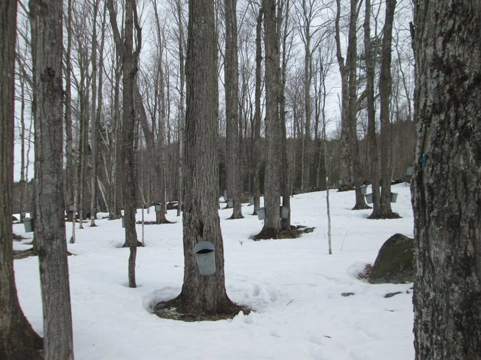
Currently the Sugar Hill Maple Farm is owned by the Hunt family, and they continue to work the sugarbush and produce local maple syrup as their ancestors did. They welcome school groups and visitors to their property to learn about the maple sugaring process during the early Spring months of March and April.
Under terms of the conservation easement, ACT may mow the farm fields to keep them open for their habitat and scenic value. For generations, residents and visitors have walked the trails through these woods, and appreciated the farm’s place in the rural culture of the community.
Creamery Pond & Whipple Pasture

Salmon Hole Brook flows through the Creamery Pond conservation area. The brook originates several miles away within the Cooley-Jericho Community Forest, and flows though lands within the Bronson Hill Conservation Area, all conserved by ACT.
Birds, bats, fish, and a host of other wildlife and people will benefit from Carl and Nancy Martland’s conservation of these two properties. The land is on both sides of Pearl Lake Road, at the corners of Hadley Road and Creamery Pond Road in Sugar Hill.
On the south side of Pearl Lake Road, 16 acres conservation land protects the Salmon Hole Brook, a cold water stream that supports wild brook trout and flows into the Ammonoosuc River in Lisbon. The land is mostly floodplain with sedge meadow, alder swamp, and the brook, and has some surrounding upland forest.
“We encourage other landowners to work with ACT as we have, to protect the rural character and native species of our wonderful area. ”
On the north side of the road, Salmon Hole Brook continues, and the 43-acre property contains floodplain, wetlands, and an upland forest that is home to black bear, all kinds of songbirds, grouse, woodcock, and deer, among other creatures.
Together, the two parcels protect nearly a ¾ mile of stream frontage. Built into the conservation agreement between is special protection for the land along the Salmon Hole Brook.
The project is part of ACT’s Clean Water/Healthy Trout initiative. The land also provides important habitat to bats, which like the mix of forest, marsh, and field.